
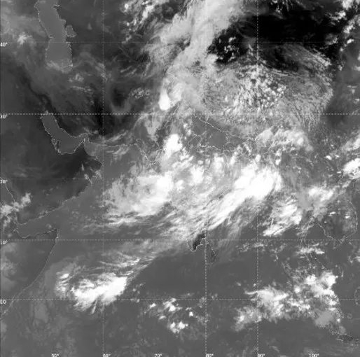
ISRO Satellite Images Show Monsoon Clouds Covering 95% of India, IMD Issues Rain Alert
Nearly 95% of India was blanketed by monsoon clouds in the early hours of Tuesday, with ISRO's INSAT-3DR and INSAT-3DS weather satellites capturing one of the season's most extensive cloud covers. The images, recorded between 2:15 am and 3:27 am, show dense cloud bands stretching from the north Bay of Bengal across Odisha, Chhattisgarh, Madhya Pradesh and Gujarat to the Arabian Sea, leaving only parts of western Rajasthan and Kutch relatively cloud free.
The India Meteorological Department (IMD) said thermal infrared imagery, which detects heat rather than visible light, revealed widespread deep cloud systems, while water vapour imagery showed abundant moisture extending from the Arabian Sea to the Himalayas, creating favourable conditions for sustained rainfall.
Satellite-derived cloud top temperature maps indicated towering cumulonimbus thunderstorms with cloud tops colder than minus 60 degrees Celsius, and in some areas below minus 80 degrees Celsius, over Bihar, the Northeast and the Himalayan foothills. These cloud tops, reaching 12 to 16 kilometres into the atmosphere, are typically associated with intense thunderstorms and heavy rainfall. Recent observations included 37 cm of rain at Williamnagar in Meghalaya and 22 cm at Shama in Uttarakhand within 24 hours.
The IMD said the monsoon trough remains close to its normal position, aided by cyclonic circulations over Punjab, southern Uttar Pradesh, the Jharkhand-Bihar region, southwest Rajasthan and Assam, along with an upper-air trough extending from the west-central Bay of Bengal to the northeast Arabian Sea. A Western Disturbance is also contributing to enhanced monsoon activity across northern and western India.
The weather office has forecast active monsoon conditions over northwest and northeast India for the next four to five days, with extremely heavy rainfall likely over Southwest Madhya Pradesh, Southeast Rajasthan, Konkan & Goa and Jammu-Kashmir-Ladakh on July 22. Heavy to very heavy rainfall is also expected across Bihar, Jharkhand, West Bengal, Sikkim and parts of the Northeast, while flash flood risks remain elevated in several Himalayan districts.
Despite the dramatic satellite imagery, IMD cautioned that the widespread cloud cover alone will not erase India's seasonal rainfall shortfall. June 2026 received just 99.5 mm of rainfall, around 40% below normal, making it the fifth-driest June since 1901, while July rainfall is still forecast to remain below the long-period average, although the current active spell could narrow the deficit.