
India Weather Today: North Bakes In Heat, South Sees Patchy Rain And Storms
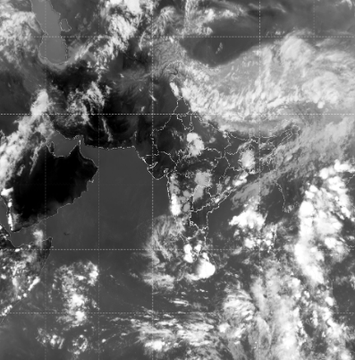
The India Meteorological Department (IMD) indicates that India will continue to experience a strong pre-monsoon weather pattern on May 8, 2026 , marked by high temperatures, humidity, and isolated thunderstorm activity across multiple regions . Daytime heat will dominate most parts of the country, while moisture-driven cloud systems will trigger uneven rainfall and lightning in scattered pockets.
In north and northwest India , including Rajasthan, Delhi-NCR, Punjab, and Haryana, temperatures are expected to range between 38°C and 45°C , maintaining heat stress conditions during the day . However, interaction between western disturbances and incoming moisture may trigger isolated thunderstorms with lightning and gusty winds of 30–60 kmph in some areas, mainly during late afternoon and evening. Light to moderate rainfall between 5–20 mm is also possible in a few pockets.
In central India , including Madhya Pradesh and adjoining regions, temperatures are likely to stay between 37°C and 43°C , with hot and dry conditions prevailing during most of the day. By evening, localized thunderstorms may develop with a 20–40% probability , bringing short spells of rain and wind gusts of 30–50 kmph , though distribution will remain highly uneven.
In eastern and northeastern India , weather activity is expected to be more widespread, with temperatures ranging from 30°C to 36°C . These regions may see moderate to heavy rainfall (10–40 mm in isolated areas) along with thunderstorms, lightning, and gusty winds of 30–50 kmph , especially over Assam, Meghalaya, Arunachal Pradesh, and nearby states.
In southern India , including Telangana, Andhra Pradesh, Karnataka, Kerala, and Tamil Nadu, temperatures are expected between 32°C and 43°C , with coastal areas remaining humid. There is a 20–50% chance of isolated thunderstorms , with rainfall generally in the 5–25 mm range . Interior regions may continue to experience intense heat during the day followed by evening storm formation.
Overall, India remains under a classic pre-monsoon transition phase , where daytime heat dominates (32°C–45°C range) while atmospheric instability leads to scattered thunderstorms, lightning, and gusty winds in different regions at different times .
This pattern also explains why rainfall appears to “move away” and “come back” — in reality, cloud systems keep forming and breaking apart while shifting across regions , gradually building up toward the monsoon season.