
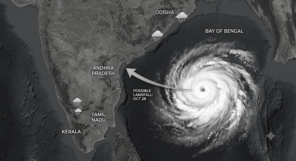
Cyclone Watch: Andhra, Odisha on Alert, Heavy Rain Continues Across Tamil Nadu
A Bay of Bengal depression is set to become a cyclonic storm on Monday and a severe cyclonic storm by October 27, and could strengthen further before crossing the Andhra Pradesh coast around October 28. The India Meteorological Department (IMD) has forecast extremely heavy rainfall in parts of Coastal Andhra Pradesh as authorities step up preparations.
The depression lay over the east-central and adjoining southeast Bay of Bengal on Sunday morning, around 880 km east-southeast of Visakhapatnam and 980 km east-southeast of Kakinada. It is likely to move west-northwestwards, becoming a deep depression and then a cyclonic storm by Monday morning.
The IMD has indicated that the system may cross the Andhra Pradesh and Yanam coasts between Bapatla and Visakhapatnam around the forenoon of October 28, with maximum sustained winds of 115-125 kmph and gusts reaching 140 kmph.
Heavy rainfall is forecast in Coastal Andhra Pradesh on October 26, followed by extremely heavy rain at isolated places on October 27 and 28. Heavy rain is also likely on October 29. Thunderstorms accompanied by lightning are expected in parts of Coastal Andhra Pradesh, Yanam and Rayalaseema.
The Fisheries Department has advised fishermen not to venture into the sea until October 29 and directed boats already at sea to return immediately. Of the state’s 30,043 fishing boats, 29,952 had returned safely by Saturday, while the remaining 91 were heading towards the coast under continuous monitoring.
Meanwhile, the Northeast Monsoon continues to bring intense rainfall to Tamil Nadu. The IMD has forecast very heavy rain in parts of the state on Monday, with several districts facing further downpours.
The situation has already turned serious in the Nilgiris, where heavy rain triggered landslides and tree falls. A state transport bus driver died after mud and uprooted trees buried his vehicle near Burliar, while the conductor was rescued. Tourist spots were closed and restrictions imposed on traffic along vulnerable hill roads.
Coastal authorities and disaster-management agencies are monitoring the system’s movement and preparing for heavy rain, strong winds and possible disruptions over the coming days.